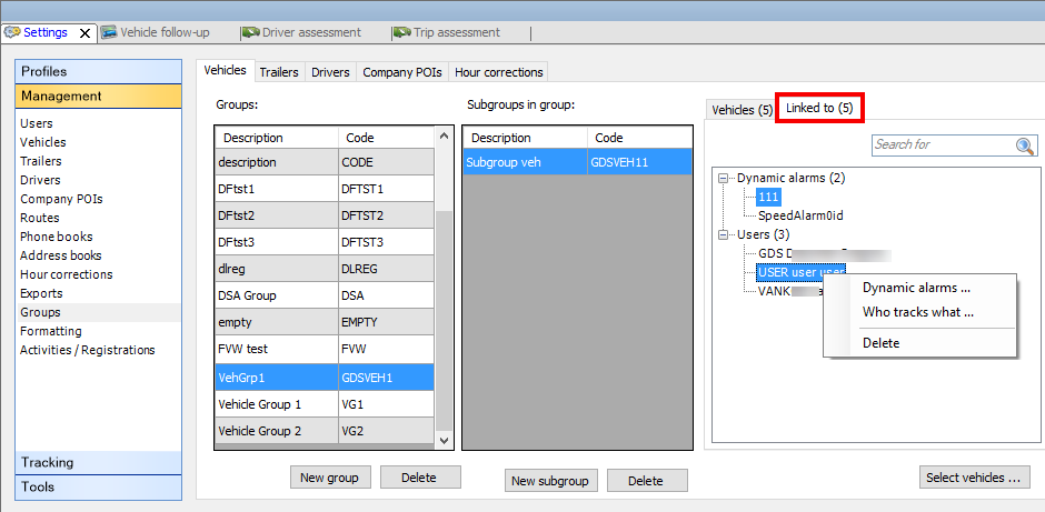
The "Groups" management screen allows you to manage your vehicles, trailers, drivers, company POIs and hour corrections.
The window contains different pages, divided into columns:
● Groups
● Subgroups in group (not applicable to hour corrections)
● Vehicles / Trailers / Drivers / Company POIs / Hour corrections in (sub)group
● Linked to (available as from TX-CONNECT version 11.45.28): View items linked to the selected subgroup
Add / delete a new (sub)group
At the bottom of each column, you can add or delete items. Note that the "Who tracks what" functionality has no influence on the management of groups and vice versa.
|

|
- Firstly, create a group.
|
|

|
- Create a subgroup in the group (not applicable to hour corrections).
|
|
|
- Depending on the selected tab page, add vehicles / trailers / drivers / company POIs / hour corrections to the subgroup (or to the group in case of hour corrections).
|
|

|
The created (sub)groups will then be visible in the relevant selection / filter screens.
|
(TX-SKY only - not active by default)
As from TX-CONNECT version 11.45.28, you can view which items are linked to the selected subgroup in the "Linked to" tab page in Settings > Management > Groups.
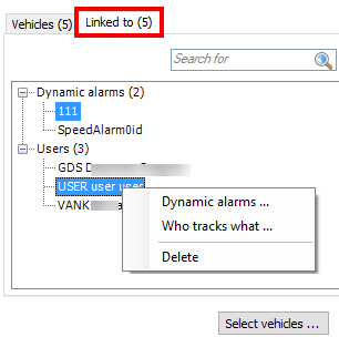 |
Right-click on an item in the "Linked to" tab page to view the context menu options:
-
Shortcut to other modules to link new items to the subgroup: "Dynamic alarms", "Who tracks what", "Hour corrections" (available options depend on the selected group (vehicles, trailers, drivers or company POIs).
-
Delete: Remove one or more linked item(s) from the selected subgroup
Selected tab
|
Linked items
|
Context menu options
|
|
Vehicles / trailers
|
Dynamic alarms / users
|
-
Dynamic alarms
-
Who tracks what
-
Delete
|
|
Drivers
|
Hour corrections / users
|
-
Hour corrections
-
Who tracks what
-
Delete
|
|
Company POIs
|
Users
|
|
|
In the "Company POIs" tab page, an extra button Edit icon is provided. Here, it is possible to assign an icon both to POI groups and subgroups. These icons are used to visualize the POI on the map, but keep in mind that:
● If an icon is assigned to the subgroup, the POI is displayed on the map with the subgroup icon.
● If no icon is assigned to the subgroup, but the group does, the POI is displayed on the map with the group icon.
● If no icon is assigned to both the group and the subgroup, the POI is displayed with the standard POI icon  .
.
● When several POIs are grouped on the map, the standard POI group icon is used even when other icons are assigned to the separate POIs.
● When a single POI is assigned to different subgroups, each with their own icon, then the first available icon is used.
● When adding a new (sub)group, the standard POI icon is used. Click on the icon drop-down box to view all icons that can be selected. If none of the icons fits your purpose, you can choose "New" in the drop-down list, allowing you to browse for your picture. The supported picture types are: ico, bmp, jpg, png and gif (32x32 pixels). Large images will be automatically compressed to make them fit on the map.

Back to Settings - General overview