|
SHOW ACTIVITY ON MAP |
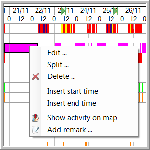
To view the position of a vehicle during an activity or the route the driver has travelled on map, right-click on the specific activity block and select "Show activity on map".
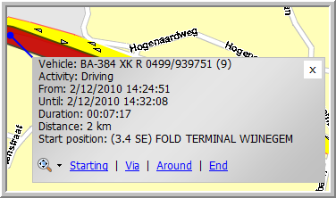
The map will automatically open displaying the position / route in the same colour as the activity. A box shows you the corresponding vehicle, the activity, the starting and end time of the activity, the duration of the activity and, in case of the activity "Driving", the distance that was covered.
To close the info boxes, click on the black arrow next to the  icon and select "Close all", "Close all address info", "Close all activity info" or "Close all route info". When you select "Close all", all info boxes will be closed, i.e. the activity, the address and the route boxes.